 |
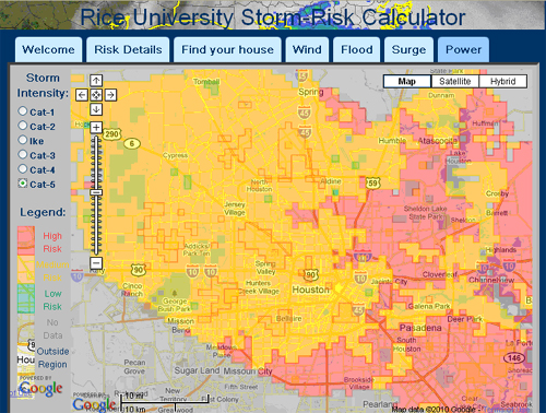
Hurricane Risk Assessment for Informed Evacuation DecisionsPrincipal Investigator: Dr. L. Dueñas-Osorio, Rice University Project Goal: To develop an online tool that City of Houston citizens can use to determine the magnitude of the risks they could face when exposed to hurricane events. The “Storm Risk Calculator” provides estimates at the neighborhood level of the consequences of being exposed to wind, flood, surge, as well as the likelihood of power outages. Citizens empowered with this information, in particular those who live outside evacuation zones, can plan for intra-city evacuation or time their evacuation to not conflict with evacuees from mandatory evacuation zones. Background: The Houston metropolitan area is home to over 5.5 million inhabitants; it is the fourth-largest in the United States. When Hurricane Rita bore down on Houston, 2.5 million Houston area residents were evacuated, making it the largest evacuation in the history of the United States. Critics of the evacuation process believe that authorities waited far too long to permit outward-bound cars to use both sides of the Interstate highways. It is estimated that residents who decided to leave Houston, and that did not need to evacuate, had a significant impact in the mobility of populations at true risk. Indeed, if a mere 15% of Harris County residents inside the loop had sheltered in place in their homes, the transportation system could have absorbed evacuees from the more vulnerable Galveston area. Instead, thousands of residents clogged major freeways and witnessed gasoline shortages, and difficult recovery. The proportion of shadow evacuees from hurricane Ike was no different than that from Rita, but since the overall total evacuation was smaller, evacuations ran smoothly (a different outcome would have been observed with had hurricane Ike been a category 4 at landfall). The need for good planning and information integration tools which can help regional authorities develop sound evacuation and sheltering policies has never been more critical. Status Report (June 2010): A beta version of the “Storm Risk Calculator” is already under testing among a small subset of users. The flood, surge, wind, and power outage risk modules have been validated against historical information, and their core engines upgraded to use the latest methods for inundation assessment, fragility modeling of residential homes, and vulnerability of power distribution lines. A snap shot of the website is presented in Figure 1 below. Report completion anticipated for August – 2011.
|